Getting started
Here we walk you through how to use this package.
import pandas as pd
import openap
from traffic.core import Flight
import gedai
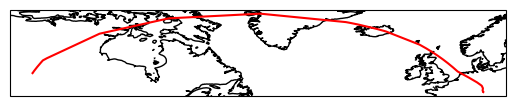
The first step is to load the raw ADS-B data. For this example, we are going to follow the DLR’s HALO (D-ADLR) Gulfstream 5 research aircraft. The HALO has the unique ICAO transponder hex 3c5192. We will use the private-jets database compiled by Gössling et al. (2024) on 06/08/2022.
icao = "3c5192"
base_url = "https://private-jets.fra1.digitaloceanspaces.com/globe_history/2022-08-06/"
source = "adsb_exchange"
data, metadata = gedai.fetch_raw_data("bjets", base_url, icao)
Fetching was successful!
ac_type = "GLF6"
ac = openap.prop.aircraft(ac_type)
df = gedai.create_dataframe(data, metadata, source)
f = Flight(df)
Now let’s plot the flight.
import matplotlib.pyplot as plt
import cartopy.crs as ccrs

ax = plt.axes(projection=ccrs.PlateCarree())
ax.plot(f.data.longitude, f.data.latitude, "r", transform=ccrs.Geodetic())
ax.coastlines()
<cartopy.mpl.feature_artist.FeatureArtist at 0x7fdbeabff770>